Khyber Pass
| Khyber Pass | |
|---|---|
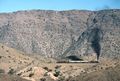
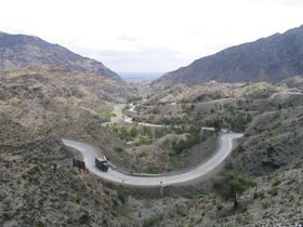 Looking back towards Pakistan, on the Pakistan side of the Khyber Pass |
|
| Elevation | 1,070 m (3,510 ft) |
| Location | |
| Location | Pakistan/Afghanistan |
| Range | Safed Koh |
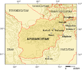
The Khyber Pass, (Pashto: د خیبر درہ, Urdu: درۂ خیبر) (altitude: 1,070 m or 3,510 ft) is a mountain pass that links Pakistan and Afghanistan.
Throughout history it has been an important trade route between Central Asia and South Asia and a strategic military location. The summit of the Khyber Pass is 5 kilometres (3.1 mi) inside Pakistan at Landi Kotal and it cuts through the northeastern part of the Safed Koh mountains which themselves are a far southeastern extension of the Hindu Kush range.
Contents |
History
In some versions of the Aryan migration theory, the Indo-Aryans migrated to India via the Khyber Pass. Recorded invasions through the Khyber begin with the conquests of Darius I and Alexander the Great and also include later Muslim invasions of South Asia, culminating with the establishment of the Mughul Empire from 1526. The British invaded Afghanistan from India and fought three Afghan Wars in 1839-42, 1878-80, and 1919. George Molesworth, a member of the British force of 1919, summarised: "Every stone in the Khyber has been soaked in blood." Rudyard Kipling called it "a sword cut through the mountains."
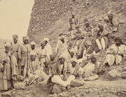
To the north of the Khyber Pass lies the country of the Mullagori tribe. To the south is Afridi Tirah, while the inhabitants of villages in the Pass itself are Afridi clansmen. Throughout the centuries the Pashtun clans, particularly the Afridis and the Afghan Shinwaris, have regarded the Pass as their own preserve and have levied a toll on travellers for safe conduct. Since this has long been their main source of income, resistance to challenges to the Shinwaris' authority has often been fierce.
For strategic reasons, after the First World War the British built a heavily engineered railway through the Pass. The Khyber Pass Railway from Jamrud, near Peshawar, to the Afghan border near Landi Kotal was opened in 1925.
During WWII concrete "dragon’s teeth" (tank obstacles) were erected on the valley floor due to British fears of a German tank invasion of India.[1]
The Pass became widely known to thousands of Westerners and Japanese who traveled it in the days of the Hippie trail, taking a bus or car from Kabul to the Afghan border. At the Pakistani frontier post, travelers were advised not to wander away from the road, as the location was then a barely controlled Federally Administered Tribal Areas. Then, after customs formalities, a quick daylight drive through the Pass was made. Monuments left by British Army units, as well as hillside forts, could be viewed from the highway.
The area of the Khyber Pass has been connected with a counterfeit arms industry, making various types of weapons known to gun collectors as Khyber Pass Copies, using local steel and blacksmiths' forges.[2][3]
A major street in the Newmarket suburb of Auckland is named after the pass.
Current conflicts
During the current war in Afghanistan, the Khyber Pass has been a major route for resupplying NATO forces in the Afghan theater of conflict. Recognizing this, the Taliban attempted to choke off the route in late 2008 and early 2009, bringing the Taliban into conflict with the Pakistani government.[4]
In February 2009, a bridge 15 miles northwest of Peshawar was blown up by militants presumably sympathetic to or sponsored by the Taliban. While it was not considered to be a major strategic blow to the allied war effort, it invigorated efforts to secure additional supply routes, some of which may ultimately run through Iran. However, the current general consensus is that the new supply route will pass through various central Asian republics to the north of Afghanistan.[5]
Conquerors and generals
The commanders who crossed the Khyber Pass all led armies eastward in the conquest of India, except for Chandragupta Maurya, Ranjit Singh and George Pollock who crossed in the opposite direction.
|
|
See also
- Khyber Pakhtunkhwa
- Khyber Agency
- Federally Administered Tribal Areas
- Durand Line
- Khyber train safari
- Pakistan Standard Time
- Carry On... Up the Khyber
- Khyber Pass Copy
Further reading
- Molesworth, Lt-Gen. G.N., Afghanistan 1919 (Asia Publishing House, 1962). This book describes in detail the author's passage (Prince Albert's)Somerset Light Infantry.
- Victor Bayley CIE CBE. "Permanent Way through the Khyber", Jarrolds (1934). In an article illustrated with photos, the author describes the construction of the railway. The book was reprinted in 1998 by Gyan Publishing House, India as Adventure through Khyber in a breach of copyright.
- In "Sorrow Rides a Fast Horse" by Dorothy Gilman Butters (Ladies Home Journal, September, 1962) a mother, grief-stricken from the death of her husband, takes her two children on a whirl-wind trip around the world. Shortly after crossing from Iraq into Iran, her family and their elderly guide are captured by bandits. They don't want just the money, the food and the donkeys. They want the woman and the children. The guide says sadly “It must by your qismat—your fate—to stop here.” She says harshly, “My qismat? Tell this man I must travel like the wind—that is my qismat. Tell him that Sorrow rides behind me on a fast horse—if he listens closely, he may hear the hoof beats. Tell him that if he captures me, he will capture Sorrow as well—because where I go Sorrow goes and where I stop, Sorrow will stop.” The bandits confer. Their leader finally makes a statement. The guide translates: “He says it has been a hard year, with many people dead in their village. Sheep have sickened and died. He says they do not wish for more Sorrow. If Sorrow follows behind you then you must leave these mountains at once. You must not stop even to sleep.” To ensure their prompt departure, the bandits guide them through the mountains to Kermanshah.
References
- ↑ Introducing The Khyber Pass
- ↑ http://www.odcmp.org/new_forum/topic.asp?ARCHIVE=true&TOPIC_ID=52881
- ↑ http://www.surplusrifleforum.com/viewtopic.php?f=96&t=26656
- ↑ http://www.nytimes.com/2009/01/03/world/asia/03pstan.html?partner=rss&emc=rss
- ↑ http://www.telegraph.co.uk/news/worldnews/asia/pakistan/4448121/Khyber-Pass-bridge-used-by-Nato-is-blown-up-by-militants.html
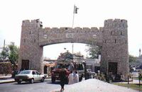
 Khyber Gate on Jamrud Road |
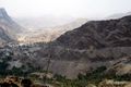 Khyber Pass looking towards Afghanistan |
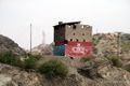 Khyber Rifles watch tower |
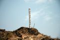 "May Peace Prevail On Earth" post |
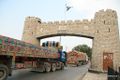 Khyber Pass Gateway southbound towards Peshawar |
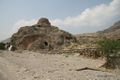 Derelict British-built railway line and ruined Buddhist Stupa |
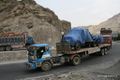 NATO forces transport activity |
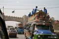
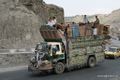 Typical Pakistani transport truck and passengers |
 Soldier with AK-47 watching Khyber Pass |
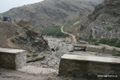 Washed out bridge |
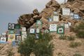 Khyber Pass Military Regiment Signs |
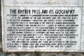 Khyber Gate Information Plaque #1 |
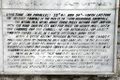 Khyber Gate Information Plaque #2 |
 Mountain passes of Pakistan |
 The Khyber Railway. With a Pakistan Railways HGS 2-8-0 at front and rear a charter train climbs the Khyber Pass through a series of zig-zags to gain height |
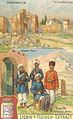 An advertisement card from 1910 depicting Khaiber Pass |